
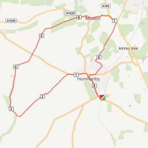
Map of Hunmanby Railway Station circular walk via the Wolds Way and Centenary Way. The numbers show the miles from Hunmanby Railway Station.
This link to the Map o Meter page for the Hunmanby Railway Station circular walk via the Wolds Way and the Centenary Way will show the map in full size, calories burnt, and gradient profile.
In the information racks on the Scarborough Platform (Number 2) there are leaflets for the Hunmanby in Bloom flower trail and the Hunmanby History Group 'Heritage trail'. Both have maps and describe the history of the village and location of the flower beds and open spaces maintained by the village community.

Photo above: Take time to look around the rear of the Southgate Bed & Breakfast at the hidden Cottage Garden and the flower beds, Market Cross and War Memorial, all looked after by the village community.
Turning right out of the station the new signs installed by Scarborough Borough Council point the way to the village along Bridlington Street, past The Folly on your left. The walk is through the heart of the village, which has good facilities. See link to what Hunmanby has to offer webpage
Continue up Church Hill, past All Saints Church on your right, continue past the K2 listed telephone box, the finger post, and Sebastopol Corner flower bed. Before crossing the road and continuing up Castle Hill and the main Malton Road, take time to take a photograph looking down Stonegate and appreciate the old chalk houses dating back to the 18th Century.

Photo above: The Sebastopol flower bed, finger post and the mount with the trees is the remains of the Norman Motte and Bailey.
The route up Malton Road is part of the Centenary Way a National Walking route, that passes through Hunmanby Village. The route is 83 miles long from York to Filey Brigg. North Yorkshire County Council have produced a 48 page booklet, that describes the route. It is available at local libraries at £4. Further details from Centenary Way website
Walk up the footpath on Malton Road (right hand side) where it ends, cross over and walk the well walked path in the grass verge up to the junction with a farm track. This is signposted 'Centenary Way.' The walk climbs up past the reservoirs and skirts round Field House Farm

Photo above: Snowdrops grow well in the chalk soils around Hunmanby, this photograph was taken late February 2020, near Field House Farm, less than a mile from the village centre

Photo above: The big skies of the Yorkshire Wolds, looking towards Hunmanby Grange, on the Centenary Way, a little over a mile from Hunmanby All Saints Church.
The path over the fields, meets a farm track, here turn right, and drop down into Cans Dale. After a few minutes there is a junction of two long distance paths. Take the Wolds Way path, straight ahead, up Stocking Dale.

Photo above: Stocking Dale on the Wolds Way, Hunmanby

Photo above: Graffiti from World War 2, in on old beech tree in the woods at Stocking Dale
It is a pleasant walk up Stocking Dale, watch out for Barn Owls, as they hut voles and mice in the hawthorn scrub. The path crosses the Malton Road at 'Happy Hens' (Stockendale Farm)

Photo above: 'Happy Hens' Stockendale Farm, where the Centenary Way crosses Malton Road
There are sea views as the Wolds Way descends into Muston. In Muston is the Ship Inn, a traditional family run free house, home cooked food, real ale and an open fire. Further details from the Ship Inn Facebook page
Follows the road through Muston, there is a little 'short cut' through the All Saints church yard. On reaching the main coast road A165, turn right and walk the short distance to the roundabout. Here look for the sign posted footpath on your right, 'Centenary Way' this leads back to Hunmanby. It is a pleasant walk over the field, with Hunmanby visible, on higher land above The Carrs. The footpath skrts round North Moor Farm, and emerges on a farm track leading to the junction of Northgate and Outgaits Lane.

Above: The old traditional bench at the end of the Centenary Way footpath from the roundabout on the A165
Then turn left and walk along Outgaits Lane, looking for a footpath sign on your right. This is Hunmanby Village Path 4, Outgaits Lane to Bowling Green Lane. A public right of way, mostly paving slabs, it can be a bit uneven and narrow in places. It is an old footpath, predating village development. Some hawthorn hedges that would have formed field boundaries remain. Snowdrops grow in the Spring. It is a popular path, used to access the village school and as a short cut to the village shops from Outgaits Lane.

Photo above: Outgaits Lane to Bowling Green Lane footpath

Map above: Village path 4, Outgaits Lane to Bowling Green Lane
The footpath ends at the junction with Stonegate, here turn right and walk past the Community Centre, formerly the village school, cross the road and look for a footpath (Church Walk) that runs from Stonegate to the heart of the village. between All Saint Church and Wrangham House Hotel. At the junction with the road (Bridlington Street) turn left and it a 15 minute walk to the railway station.
Updated 19.10.2021