

Photo Above: The 'Green' Lane in Hunmanby
Village path 1, Muston Road to High Croft. Not listed as a public right of way. A grass track short cut useful for residents in this part of the village walking to Muston. Well maintained Hunmanby Parish Council cut the grass regularly

Photo above: Footpath from Muston Road to High Croft

Map above: Village path 1, High Croft to Muston Road

Photo above: High Croft to Muston Road footpath
Village Path 2, Outgaits Lane to Mitford Close and on to Owston Road. Not listed as a public right of way. Constructed at the time the Mitford Road Estate was constructed by East Riding Council. The path is tarmac. Useful route to village school avoiding road and a short cut to access public footpath route to Filey

Photo above: Outgaits Lane to Owston Road footpath

Map above: Village path 2, Outgaits Lane to Owston Road

Photo above: Owston Road to Outgaits Lane footpath
Village Path 3, Priest Close to Bowling Green Lane. Not listed as a public right of way. Tarmac surface, well used route to access village school and route to the village shops from Mitford Road Estate and lower part of Northgate

Photo above: Priest Close to Bowling Green Lane footpath

Map above: Village path 3, Priest Close to Bowling Green Lane

Photo above: Bowling Green Lane to Priest Close footpath
Village Path 4, Bowling Green Lane to Outgaits Lane. A public right of way. mostly paving slabs, can be a bit uneven and narrow in places, an old footpath, pre-dating village development. Some hedges that would have formed field boundaries remain. Snowdrops grow in the Spring. Used to access the village school and as a short cut to the village shops from Outgaits Lane.

Photo above: Bowling Green Lane to Outgaits Lane footpath

Map above: Village path 4, Bowling Green Lane to Outgaits Lane

Photo above: Outgaits Lane to Bowling Green Lane footpath
Village Path 5, Bowling Green Lane to Wrangham Drive. Not listed as a public right of way. Short section of rough footpath that enables pedestrians a short cut to the village school and shops for residents in Wrangham Drive and Burlyn Road.

Photo above: Bowling Green Lane to Wrangham Drive footpath

Map above: Village path 5, Wrangham Drive to Bowling Green Lane

Photo above: Wrangham Drive to Bowling Green Lane footpath
Village Path 6, Cecil Road to Sheepdyke Lane. Not listed as a public right of way. A tarmacked 'snicket or ginnel' Useful short cut for residents in Cecil Road and Constable Road to access Sheepdyke lane, with its easy access to the countryside. Short cut to the shops for residents in Manor Gardens Estate.

Photo Above: Footpath from Cecil Road to Sheepdyke Lane

Map above: Village path 6, Cecil Road to Sheepdyke Lane

Photo above: Footpath from Sheepdyke Lane to Cecil Road
Village Path 7, Hamerton Close to Constable Road. Not listed as a public right of way This 'green lane' is a culverted section of a tributary of the River Hertford, the source being above Havercroft Road close to Bridlington Street. Created with the construction of the later developments of the Fountayne Road estate towards the railway line. Trees planted 20 years ago are now starting to mature. The 'green way' is well used, mown regularly by Hunmanby Parish Council. The path starts by the entrance to the younger children's play area and emerges via a 'dog leg' on Constable Road close to the junction with Grimston Road.


Map above: Village path 7, Hamerton Close play area to Constable Road
Photo Above: Hamerton Close, entrance to the 'Green Lane' The young people play area is well connected to the local estate by 'green lanes' which have been made by culverting streams and drainage channels that flow into the River Hertford

Photo above: Looking from the 'Green Lane' past the young children's play area to Hamerton close exit

Photo above: Start of the 'Green Lane' on Constable Road close to the junction with Grimston Road
Village Path 8, 'Green Lane' to Percy Road. Not listed as a public right of way. This rather narrow fenced tarmacked 'snicket or ginnel' useful link to residents in Percy Road to access 'green lane' young people play area and nice walk along Sheepdyke Lane, the nearest quiet 'country lane' in the village.

Picture Above: 'Green Lane' to Percy Road footpath

Map above: Village path 8, 'Green Lane' to Percy Road

Photo Above: Percy Lane to 'Green Lane' footpath
Village Path 9, 'Green Lane' to Strickland Road. Not listed as a public right of way. This short grassed link path useful link to residents in Strickland Road, Sands Lane and Havercroft Road to access 'green lane' young people play area and nice walk along Sheepdyke Lane, the nearest quiet 'country lane' in the village.

Photo above: 'Green Lane' to Strickland Road footpath

Map above: Village path 9, 'Green Lane' to Strickland Road

Photo above: Strickland Road to Green Lane footpath
Village Path 10, 'Green Lane' to Constable Road. Not listed as a public right of way. One of three links to the Green Lane from Constable Road. This short, grassed link path to the Constable Road garages a useful link to access 'green lane' young people play area and nice walk along Sheepdyke Lane, the nearest quiet 'country lane' in the village.

Photo above: Footpath 'Green Lane' to Constable Road by the garages. One of three footpaths that link the Constable Road estate with the 'Green Lane'

Map above: Village path 10, Constable Road garage site to 'Green Lane'

Photo above Constable Road Garage Site to 'Green Lane' footpath
Village Path 11, 'Green Lane' to Constable Road. Not listed as a public right of way. One of three links to the Green Lane from Constable Road. This short, grassed link path to the little Cul-de-Sac on Constable Road. A useful link to access the 'green lane' young people play area and nice walk along Sheepdyke Lane, the nearest quiet 'country lane' in the village.
, Hunmanby")
Photo above: 'Green Lane' to Constable Road (Cul-de-sac) footpath. The drain cover shows the course of one of the culverted former water sources that are tributaries of the River Hertford

Map above: Village path 11, Constable Road to 'Green Lane' Hamerton Close play area
 to 'Green Lane' footpath, Hunmanby")
Photo above: Constable Road (Cul-de-sac) to 'Green Lane' footpath
Village Path 12, Cowlings Close to Sands Lane. Not listed as a public right of way. Tarmac path with cycle chicane at both ends of the 'snicket or ginnel' Useful short cut to the Industrial Estate and railway Station for residents on Havercroft Road and Cowlings Close

Photo above: Cowlings Close to Sands Lane footpath

Map above: Village path 12, Cowlings Close to Sands Lane

Photo above: Sands Lane to Cowlings Close footpath
Village Path 13, Fountayne Road to Rowedale Close. Not listed as a public right of way. Tarmac path, 'snicket or ginnel' useful short cut to the Doctors Surgery and Community Centre

Photo above: Footpath from Fountayne Road to Rowedale Close

Map above: Village path 13, Fountayne Road to Rowedale Close

Photo above: Footpath from Rowedale Close to Fountayne Road
Village Path 14, Rowedale Close to Hungate Lane. Not listed as a public right of way. Tarmac path, 'snicket or ginnel' useful short cut to the Doctors Surgery and Community Centre

Photo above: Rowedale Close to Hungate Lane footpath, Hunmanby

Map above: Village path 14, Rowedale Close to Hungate Lane

Photo above: Hungate Lane to Rowedale Close footpath
Village Path 15, Hungate Court to Bridlington Street. Not listed as a public right of way. Block paving path, 'snicket or ginnel' useful short cut to the village centre

Photo above: Hungate Court to Bridlington Street footpath

Map above: Village path 15, Hungate Court to Bridlington Street

Photo above: Bridlington Street to Hungate Court footpath
Village Path 16, Vicarage Close to Hungate Court Entrance. Not listed as a public right of way. A short tarmacked path that links Vicarage Close to Hungate Lane and a shorter walking route to the heart of the village
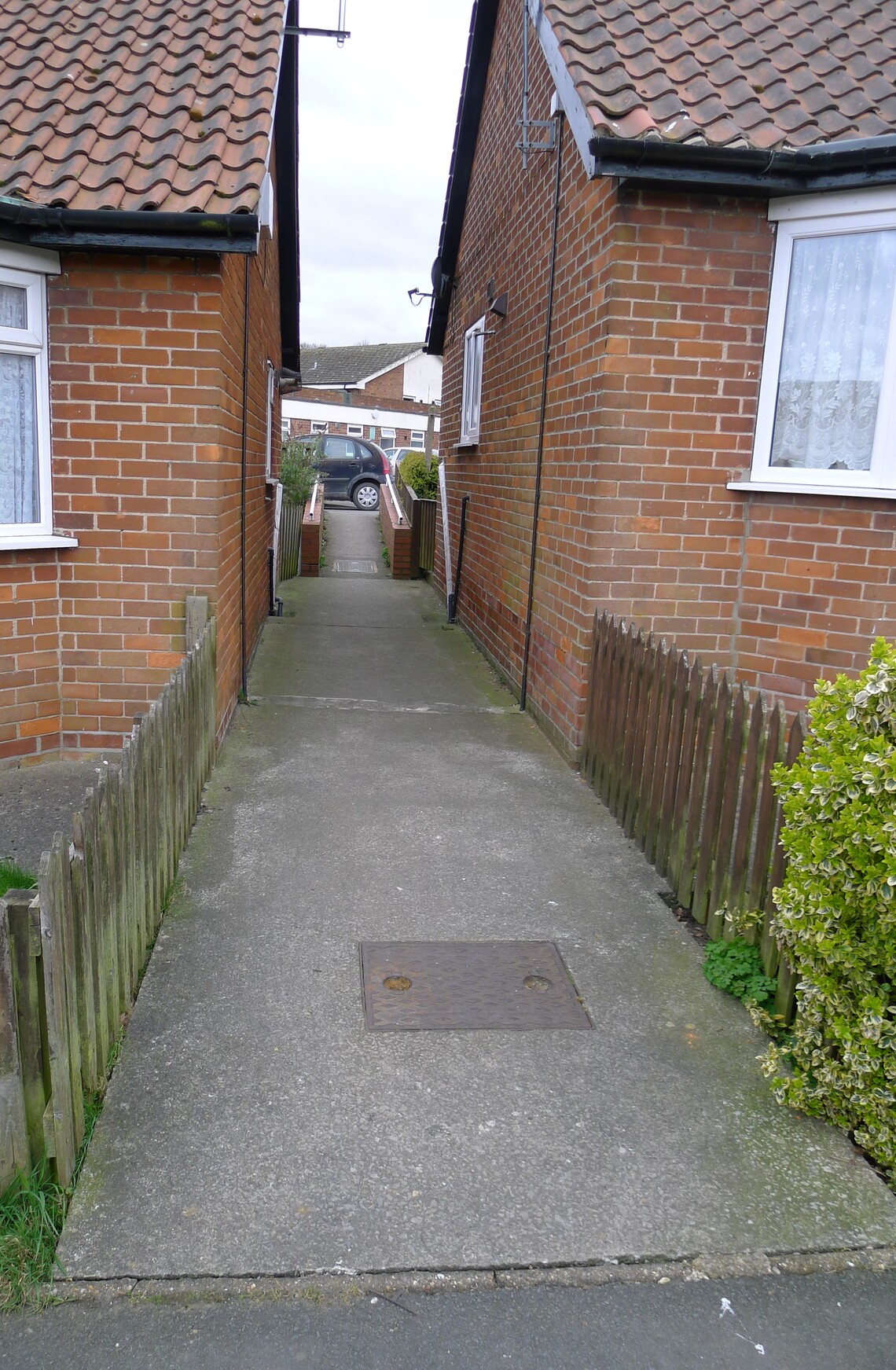
Photo above: Vicarage Close to Hungate Court entrance footpath

Map above: Village path 16, Vicarage Close to Hungate Court entrance footpath

Photo Above: Hungate Court entrance to Vicarage Close footpath
Village Path 17, Vicarage Close to Hungate Court near junction with Hungate Lane. Not listed as a public right of way. A short tarmacked path that links Vicarage Close to Hungate Lane and a shorter walking route to the doctors surgery and bus stop.

Photo above: Vicarage Close to Hungate Court near junction with Hungate Lane, foopath

Map above: Village path 17, Vicarage Close to Hungate Court, near junction with Hungate Lane

Photo Above: Hungate Court, near to junction with Hungate Lane, footpath to Vicarage Close
Village Path 18, Vicarage Close to Stonegate. Not listed as a public right of way a concrete path, 'snicket or ginnel' useful short cut to the HunFree Fridge and Community Centre

Photo above: Vicarage Close to Stonegate footpath

Map above: Village path 18, Vicarage Close to Stonegate

Photo above: Stonegate to Vicarage Close footpath
Village Path 19, Stonegate to Church Hill. (Church Walk) Not listed as a public right of way. Tarmac path with mature hawthorn hedge one side (All Saint Church) and grass frontage to Wrangham House Hotel cut by Hunmanby Parish Council. Pleasant historic walking route into the heart of the village, well used

Photo above: 'Church Walk' Stonegate to Church Hill footpath, Hunmanby

Map above: Village path 19, Stonegate to Bridlington Street, 'Church Walk'

Photo above: Church Walk, Church Hill to Stonegate footpath
Village Path 20, Access from Church Hill or Church Walk. A circuit around All Saint Church yard. Not listed as a public right of way. The churchyard is well maintained, the paths are tarmac, though steep in places. Primroses grow wild in the churchyard. Convenient for Spring Cafe.

Photo above: Entrance to the Churchyard footpath from Church Walk

Map above: Village path 20, All Saints Churchyard circuit, from Church Walk, Church Hill and Bridlington Street

Photo above: All Saints Churchyard footpath to Church Walk

Photo above: All Saints Churchyard footpath to Church Hill entrance

Photo above: Church Hill entrance to All Saints Churchyard footpath, Hunmanby

Photo above: All Saints Churchyard footpath, under Admiral's Arch to Church Hill

Photo above: Admiral's Arch, Church Hill, entrance to All Saints Churchyard footpath
Village Path 21, Constable Road to Howes Road. Not listed as a public right of way. Tarmac path, 'snicket or ginnel' useful short cut to the heart of the village from Constable Road, Cecil Road and Hamerton Road, likewise from Fountayne Road, Howes Road and Watson Close to towards the young children play area and Sheepdyke Lane.

Photo above: footpath from Constable Road to Howes Road

Map above: Village path 21, Constable Road to Howes Road

Photo above: footpath from Howes Road to Constable Road
Village Path 22, Constable Road public open space, crossing Howes Road, to Constable Road close to the junction with Grimston Road. Not listed as a public right of way. A 'green lane' well maintained with the grass cut by Hunmanby Parish Council. A nice walk avoiding the roads to reach Hamerton Close young children's play area and Sheepdyke Lane country lane.

Photo above: Constable Road 'Green Lane' footpath, the public open space is to the right.

Map above: Village path 22, Constable Road to Howes Road to Constable Road

Photo above: Constable Road 'Green Lane' to Howes Road

Photo above Howes Road to Constable Road 'Green Lane' footpath

Photo above 'Green Lane' looking from Howes Road towards Constable Road

Photo above: Constable Road, close to the junction with Grimston Road, 'Green Lane' to Howes Road
Village Path 23, Sands Lane to the Hunmanby Allotment Car Park. Not listed as a public right of way. This track formed of crushed stone, leads under the height barrier and up the side of the Hunmanby Playing Fields to access the open space which is Hunmanby Allotment.

Photo above: Sands Lane to Hunmanby Allotments footpath

Map above: Village path 23, Sands Lane to Hunmanby Allotments
Village Path 24, Circuit around Hunmanby Allotment. Not listed as a public right of way. Hunmanby Allotments are one of a diminishing number of allotments in the country where the public can walk round. (due to anti-social behaviour) The surface is grass, ample space for social distancing, views up to Croom Acre Plantation, the Yorkshire Wolds, and public access to the Community Orchard and pond.

Photo above: Summer on Hunmanby Allotments, view to the Yorkshire Wolds and Croom Acre Plantation

Map above: Village path 24, Hunmanby Allotments circuit

Photo above: The 2nd Community Orchard at Hunmanby Allotments.
Village Path 25, Sands Lane to Hunmanby Industrial Estate Road. Not listed as a public right of way. This track has a barrier to prevent it being used as a through route by vehicles. It runs past the Hunmanby Playing Fields Association Club House, past the Crown Green Bowling Club and round the barrier to join the Industrial Estate Road

Photo above: Sands Lane to Hunmanby Industrial Estate Road footpath.

Map above: Village path 25, Sands Lane to Hunmanby Industrial Estate Road to Bridlington Road

Photo above: Hunmanby Industrial Estate Road to Sands Lane footpath
Village Path 26, Woodland Walk. From the barrier on the Industrial Estate Road, opposite Deep Sea Electronics to the Allotment Car Park. Not listed as a public right of way. This well used path leads through an area planted with trees 20 years ago, and the first community orchard. In Spring there is a good display of bulbs by the side of the path

Photo above: Hunmanby Industrial Estate Road to Woodland Walk footpath

Map above: Village path 26, Hunmanby Industrial Estate Road to Hunmanby Allotments, 'Woodland Walk'

Photo above: The 1st Community Orchard and Woodland Walk, Hunmanby Allotments
Village Path 27. Parkland Walk. This path starts and finishes at Hunmanby Hall Golf and Leisure Car Park on Hall Park Road. Not listed as a public right of way. There is a £1 honesty box (50p for children) on the Gym Building wall. The parkland around the site forms a 1 mile training track, mountain bike cycle track, as well as a recreational walk for all. Excellent views of Bempton Cliffs, Wildlife all around – come and see the wonderful natural habitats within the parkland, with a wide variety of flora and fauna. Sightings of over 30 bird species recorded, including Barn Owl, Tawny Owl and Heron. Deer and fox are regular visitors. Bluebells, wild orchid, snowdrops, and reed bed on site.

Photo above: Entrance to the Parkland Walk

Map above: Village path 27, Hall Park Road, 'Parkland Walk'

Photo above: Parkland Walk in Spring

Photo above: Winter frost, the historic Ha-ha around Hunmanby Old Hall
Village Path 28. God' Acre, Bridlington Street. To enter the site the main entrance is at Bridlington Street, with a further entrance a third of the way up New Road. God's Acre is run by the community and is well cared for, with level access paths and several benches. The site has mature trees and spring flowers, snowdrops, and primroses in the Spring

Photo above: God's Acre view to Croom Acre Plantation

Map above: Village path 28, Bridlington Street, God's Acre circuit

Photo above: Entrance to God's Acre footpath through the top gate on New Road
Rural Village Path 29, Centenary Way from Malton Road, a long-distance public footpath going to York. This is signposted from the Malton Road junction with the tarmacked track towards Field House Farm. The route then heads onto the Yorkshire Wolds, with views to Hunmanby Grange, before descending into Stocking Dale where its route is shared with the Wolds Way.

Photo above: Malton Road, Centenary Way footpath towards Windmill Farm

Map above: Village path 29, Malton Road to Stocking Dale, 'Centenary Way'

Photo Above: Snowdrops in Spring by Windmill Farm, Hunmanby

Photo Above: The Centenary way, one mile from Hunmanby, big skies.
Rural Village Path 30, Centenary Way from Northgate Junction with Outgaits Lane, a long distance public footpath going to Filey. This is signposted and is a rough track as far as North Moor Farm. The route is involving a couple of stiles. It is a pleasant walk over the fields, crossing, Main Drain a tributary of the River Hertford. The path emerges at the roundabout on the A165 junction with the A1039 that leads into Filey. The Centenary Way avoids the main road and accesses Filey via Muston Grange Farm.
Photo above: Northgate to Filey footpath

Map above: Village path 30, Outgaits Lane to Coble Landing, Filey. 'Centenary Way'

Photo above: Approaching Northgate Farm on the Centenary Way, Hunmanby

Photo above: The view from Muston Grange towards Speeton
Rural Village Path 31, Long distance public footpath, Wolds Way from Stocking Dale to Malton Road on to Muston and Filey. This footpath is well signposted and enables a longer circular walk options in conjunction with the Centenary Way and other footpaths that link Hunmanby with Filey.

Photo above: Stocking Dale on the Centenary way, Hunmanby

Map above: Village path 31, Stocking Dale to Filey Railway Station. 'Wolds Way'

Photo above: Graffiti from World War 2, in on old beech tree in the woods at Stocking Dale

Photo above: 'Happy Hens' Stockendale Farm, where the Centenary Way crosses Malton Road
Rural Village Path 32, Outgaites Lane to Royal Oak and onto Filey via Lowfield Farm. This public footpath is well signposted, it is over the fields to the Royal Oak and crosses Main Drain a tributary of the River Hertford. The stretch of path close to the village can be rather muddy in winter months.

Photo above: Outgaits Lane to Royal Oak footpath

Map above: Village path 32, Outgaits Lane to Crescent Gardens, Filey

Photo above: The Outgaits Lane to Royal Oak footpath can be muddy in winter

Photo above: Outgaits Lane to Royal Oak footpath, village volunteers improving the footpath Summer 2020

Photo above: Royal Oak to Outgaits Lane footpath

Photo above: View back to Hunmanby after crossing the coast road at Hunmanby just before Royal Oak Level Crossing

Photo above: Haw frost near Lowfield Farm, winter of 2006
Rural Village Path 33, Primrose Valley Garage to Filey. This public footpath is well signposted, it involves walking first along Filey Road, crossing the A165 and looking for the footpath that leads through a thin plantation of Ash, sadly suffering from Ash dieback, then a cleared marked path over Filey Golf Course, and a walk along the cliff top path into Filey Glen Gardens.

Map above: Village path 33, Filey Road to Glen Gardens, Filey
Rural Village Path 34, Primrose Valley Garage to Filey via Primrose Valley. This again involves walking first along Filey Road, crossing the A165 and going walking along the footpath alongside Primrose Valley Road, then taking the footpath down to Primrose Valley Beach and the option of walking along the beach to Filey (tide dependent) or along the Cliff Top path described on Rural Village Path 30

Map above: Village path 34, Filey Road to Martin's Ravine, Filey
Rural Village Path 35, Hunmanby Gap Cafe to Hunmanby Gap Beach. This walk involves walking along Sands Road from Hunmanby and crossing the A165 coast road, then taking the road to Hunmanby Gap Cafe and the footpath down to the beach. This then gives option to walk on to Filey along the beach or return to the village via Primrose Valley.

Photo above: Sands Road, brow of the hill at Moor Farm, with view of the sea at Hunmanby Gap

Map above: Village path 35, Sands Lane and Sheepdyke Lane to Hunmanby Gap Beach

Photo above: Hunmanby Gap footpath to Hunmanby Gap Beach

Photo above: Hunmanby Gap beach, with Filey in the background and World War II structure in the foreground

Photo above: Hunmanby Gap beach, looking towards the chalk cliffs of Speeton
Rural Village Path 36, Bridlington Street to Bartindale Road. This public footpath is well signposted from Bridlington Street, it offers good views to the Yorkshire Wolds and the coast, climbing up to the Grass Track which it skirts round just follow the posts with yellow paint on the top of them to show the way. By the green container continue either to Bartindale Road climbing over a stile in the hedge, or at this point take path 37 which avoids climbing the stile. Scarborough Auto Grass club operate their circuit a limited number of weekends each year. Their staff will help you if you are using the path on these days. The dates for the Auto Grass Club on Bartindale Road this year 2021, from 11am, are:
Sunday 11th April, Sunday 2nd May, Sunday 16th May, Sunday 13th June, Sunday 4th July, Sunday 25th July, Sunday 12th September, Sunday 26th September and Sunday 10th October

Photo above: Village path 36 from Bridlington Street (God's Acre) to Bartindale Road

Map above: Village path 36, Bridlington Street to Bartindale Road
 footpath, Hunmanby")
Photo above: Village path 36, Bartindale Road to Bridlington Street (God's Acre)
Rural Village Path 37, From the Grass Track Circuit to Bartindale Road opposite Saxdale House Farm (avoids using the style)
This extra path, has kindly been created by Scarborough Auto Grass Club from the green container to another entrance on Bartindale Road, with a pair of black painted metal barriers opposite Saxdale House Farm. This is usefully especially for visitors staying in accommodation on Bartindale Road and residents in the area, it also avoids climbing the style on Path 36 into Bartindale Road. (For dates of the Scarborough Grass Track events please see details about path 36 above.)

Photo above: Village path 37, From the Boundary track on Scarborough Auto Grass Track to Bartindale Road
Updated 20.10.2021