
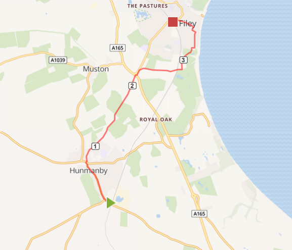
Map of Hunmanby Railway Station to Filey Railway Station via Primrose Valley Beach. The numbers show the miles from Hunmanby Railway Station.
This link to the Map o Meter page for the Hunmanby Railway Station to Filey Railway Station via Centenary Way will show the map in full size, calories burnt, and gradient profile.
This route starts at the village railway station, it gives the option of returning by train, or choosing one of the other walking routes back to Hunmanby to make a longer circular walk.
In the information racks on the Scarborough Platform (Number 2) there are leaflets for the Hunmanby in Bloom flower trail and the Hunmanby History Group 'Heritage trail'. Both have maps and describe the history of the village and location of the flower beds and open spaces maintained by the village community.

Photo above: Take time to look around the rear of the Southgate Bed & Breakfast at the hidden Cottage Garden and the flower beds, Market Cross and War Memorial, all looked after by the village community.
Turning right out of the station the new signs installed by Scarborough Borough Council point the way to the village along Bridlington Street, past The Folly on your left. The walk is through the heart of the village, which has good facilities. See link to what Hunmanby has to offer webpage
Continue up Church Hill, past All Saints Church on your right, walk past the K2 listed telephone box, and the finger post to your left at the Sebastopol Corner flower bed. Take time to look and take a photo down Stonegate to appreciate the old chalk houses dating back to the 18th Century, before crosses to the other ide of the road, and walking down Northgate

Photo above: The Sebastopol flower bed, finger post and the mount with the trees is the remains of the Norman Motte and Bailey.
Walk along Northgate, the route of the Centenary Way, with views over to the North Sea. At the end of Northgate, continue straight on, along the farm track that leads to North Moor Farm

Above: The old traditional bench at the start of the footpath to Filey

Photo above: The farm track approaching North Moor Farm
At North Moor Farm take the footpath over the fields to the main coast road. It emerges by the roundabout and then walk the short distance along the road into Filey (A1039) to the entrance to Muston Grange (on your right hand side) It is then a pleasant walk along the farm track. The footpath passes over the railway line by a brick railway bridge and past the Donkey Field. Then head towards the car park to your left.
Rather than walk down Martin's Ravine you can choose a network of paths through Crescent Gardens which are well maintained by Scarborough Borough Council, Filey in Bloom and Friends of Filey Parks. Further details from Filey in Bloom Facebook page and Friends of Filey Parks Facebook Page The walk passes the band stand, full details of concerts from Filey Town Council Band Stand Webpage. Then walk around the rear of the Evron Centre and up Murray Street, Station Avenue, past the bus station with public toilets and yup Station Approach to the Grade II* listed Filey railway station. Further details of the history of the station from the Wikipedia Filey Railway Station webpage
This link gives you details of current train departures from Northern Rail at Filey railway station. So giving the option of walking back to Hunmanby by a different route or catching the train to Hunmanby from Platform 1 (this platform has the ticket machine as Filey station is unstaffed.
Updated 19.10.2021