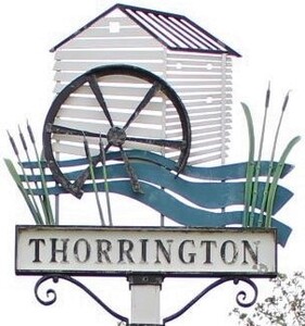
Thorrington is a small village just to the north of Brightlingsea, between the towns of Colchester and Clacton. It is a ribbon community, based around the crossroad of the B1027 and B1029. Today it is made up of just over 500 households and boasts a pub, village shop and post office. There is a small industrial estate at the crossroads, a number of residential care facilities and a scout camp. The village hall provides a community hub.
History
Mentioned in the Domesday Book as Torinduna, the name has taken may forms before settling on its current spelling. From hand written sources held by the Church confirm many of these including in 1594 when it was known as Thurrington. Up until recently it was still common to see it spelt as Thorington.
The railway station was opened in 1867 but closed in 1957, the nearest station now is Great Bentley.
On the 7th November 1929 Thorrington Parish Council officially purchased an area of land from the Reverend Charles Frederick Hutton, Rector of the Parish, for the sum of thirty eight pounds and ten shillings. This land lies to the south of Clacton Road and is accessed between March House and Bramble Cottage and is now used for the provision of allotments for the village.
On 12th July 1960 Thorrington Parish Council sold a portion of this land to the Eastern Gas Board for the sum of twenty four pounds and five shillings, for the purpose of laying and maintaining gas mains. The gas board covenanted with the Council to do as little damage as possible to the surface of the land and the crops growing thereon and agreed to pay compensation for any damage done.
At a meeting of the Parish Council on 8th August 1930 Frank Disney Girling, a farmer of the Hall Thorrington, officially gifted a parcel of land to Thorrington Parish Council for the purposes of the Recreation Grounds Act 1859. The area measured two acres, two rods and twelve perches and was part of Pound Farm. This is the area we now know as the Playing Field situated along the side of Chapel Lane.
War
As in all cities, towns and villages across the United Kingdom, Thorrington men went to fight in both world wars. The names of those killed in the conflicts are recorded on the memorial clearly visible on the front of the village hall. The Local History Recorders have researched each of the names and provided the parish with the document linked below. If you would like information on our neighbouring villages please contact them as they have similar details for each village, a link to their website is at the bottom of this page.
Thorrington War Memorial - Rob Butcher, Local History Recorder
Water
Being close to the coast the village has a contributory water running past which is utilised by one of the last working tide mills in the country. Tenpenny Brook forms the boundary between the village and neighbouring Alresford. It is along this water course that Thorrington Tide Mill stands, where the brook flows into the Alresford Creek. The mill was built in 1831 and is now a Grade II* listed building. Another tide mill, no longer surviving, was situated where the Saltwater Brook flows into Flag Creek.
Worship
The medieval period church dates from the 14th Century and is dedicated to Mary Magdalene. Under the Church of England, the patrons of the church are St John's College, Cambridge, who also own much of the land throughout the village. Today they have an active church community as part of the Tenpenny Villages Benefice and are continuing the long tradition of bell ringing in their tower.
The former Methodist chapel can be found on the corner of Chapel Lane and Church Road, opposite the village hall but is today a private residence. Built in 1905 it was also the meeting place of the Parish Council for many years. It last held a church service in 2001, the war memorial to the fallen was relocated and the building was put up for sale at auction the following year.
Further information
For other sources of information regarding the history of Thorrington and the surrounding area please use the following links:
Tendring District Historic Environment Characterisation Project 2008 (See Section 3.1.17 HECA 17 - page 82)
The local area is supported by the Tendring District Local History Recorders who collect and maintain archives of information. They have recently provided the Parish Council with a copy of their latest version of the history that they have of the village. For more information about them check out their Facebook page.
History of Thorrington (2022) - Rob Butcher, Local History Recorder
History of Thorrington (2023) - Rob Butcher, Local History Recorder
Thorrington History Group - Facebook group
Historical parish records, including minutes of the Parish Council meetings before 2006 can be accessed at the Essex Record Office
Minutes of Parish Council meetings from 2006 until 2015 can accessed by contacting the Clerk to the Council. Records of meetings from 2016 onwards can be found on this website on our Minutes page.
