LINKS
[Car Park Report No. 01 19/02/12]
[Car Park Report No. 02 23/03/12]
HANKLEY COMMON CAR PARKS REPORT No 2
Michael Organe 23/03/12
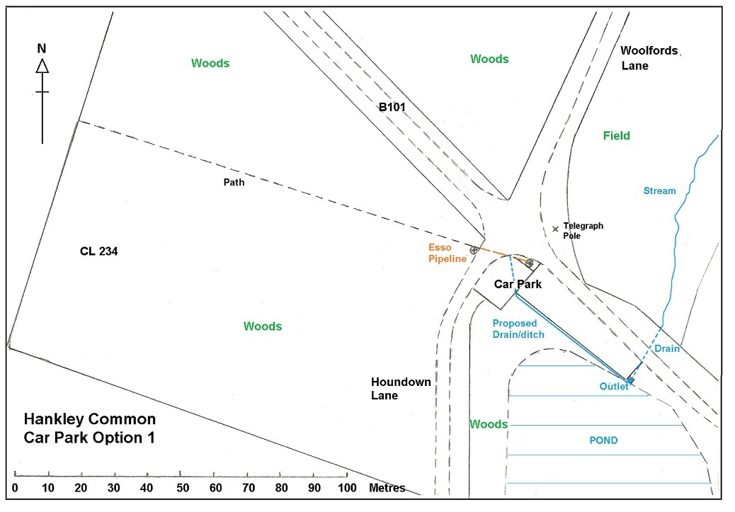
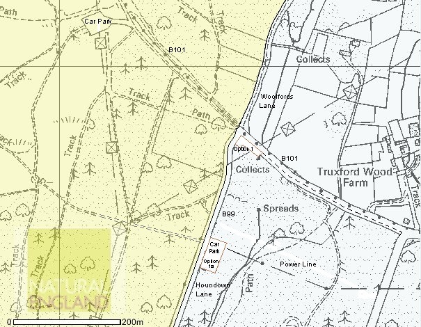
Detailed surveys of Options 1 & 1a
OPTION 1
OPTION 1a
GENERAL
OTHER PARKING AREAS
DZ PARKING USAGE
STATUS OF B101.
[TOP of page]
Protect Access to Hankley Common – Report No. 1
Michael Organe - 19/02/12
Introduction
The MoD wants to close the central Truxford Lane car park on Hankley Common, in order to meet an increased need for military training in the UK. The car park is on military land and there is no obligation to provide this facility for the public, although it has been used by them for about forty years and it would be badly missed by many regular visitors to this beauty spot.
This report is intended to set out relevant information available to PATH in order to facilitate future discussions and decisions.
It is based on MoD statements and information discovered during investigations by PATH members, as well as comments from users of the Common.
Geography of the Common
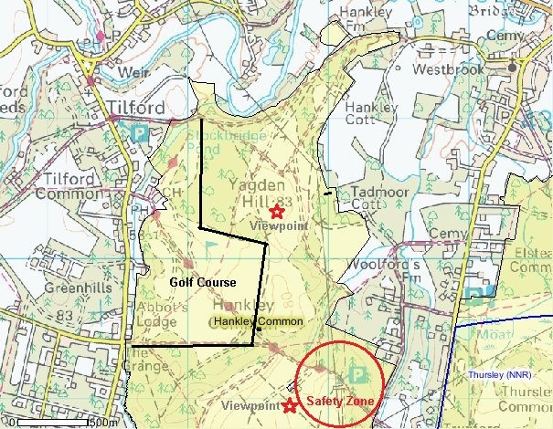
Hankley Common North & South
Hankley Common is an area of heath land in Surrey most of which is used by the MoD for military training. It is also used by the public for horse and cycle riding and for walking, many with dogs. Nearby villages include Elstead, Tilford, Rushmoor and Thursley. It is partly open heath land, partly open mixed woodland, with some forest plantations and abundant self sown pine saplings.
The Common is crossed by registered bridleways and is bounded by Tilford Road on the West, Thursley Road (Churt) to the South and Woolfords Lane and Houndown Lane to the East. In the North, Bridleway 73a runs near the boundary, along the edge of the River Wey valley. It has a southern area, approximately 2km x 2km square and an irregularly shaped northern area of about 2km x 0.75km. They are divided roughly by the bridleway running east from Grange Road to the Lions Mouth.
The bridleways are open for use by horse and cycle riders as well as walkers and runners. There are also many unregistered tracks on the Common and the MoD allows walkers and runners to use these on a permissive basis. They can also be used by horse riders if they have a permit. Cyclists are not legally entitled to use these tracks but generally the MoD and Landmarc have not enforced this in the past.
The Dropping Zone is a low-lying open area of the Common, East of Kettlebury Hill, and is surrounded by sandy ridges. It is used for military exercises, including blank firing and the use of pyrotechnics (fireworks). There are huts and a military car park at the northern end of the Dropping Zone.
The southern area round Gold Hill and Kettlebury Hill and across the Dropping Zone to Houndown Lane is owned by the MoD and is not registered Common Land, the area North of the Lions Mouth is registered Common Land and is partly leased by the MOD from the Hankley Common Golf Club. There is also a small separate area of registered Common Land on the eastern side. The majority of Hankley Common is a Site of Special Scientific Interest and it has other protective designations.
Public authorities involved in the management of Hankley Common include Surrey CC, Waverley BC, Elstead PC, Surrey Wildlife Trust and Natural England, as well as the MoD and Landmarc, their private management company.
There are five car-parking areas on the Common:
- Tilford car park
- Stockbridge Pond,
- Pitch Place,
- Westbrook Hill
- The Drop Zone central visitors’ car park.
Tilford and Stockbridge Pond are public car parks at the Northwest corner of the Common.
Pitch Place in the South is a very rough parking area off the Thursley Road. The Army uses it as a “harbour area” for military vehicles during exercises and they also allow public parking. It used to be about three times the area but a large part has been closed off by Landmarc.
Westbrook Hill parking area is a small muddy turning circle at the edge of the Northeast corner of the Common with space for a few cars. There used to be a larger parking area further into the Common but it was closed by Landmarc, citing joyriding and burnt out cars as the reason.
The DZ central visitors’ car park. This is used by the Army as a car park for groups of trainees during exercises, mainly in small buses. It has also been used for roughly the past forty years by the public, for access to the viewpoint on the ridge above the car park. It is well drained and has a good hard surface and is ideal for its purpose. It is approached from the Thursley Road on the East up a section of Bridleway 101 that was surfaced by the MoD sometime after 1950, referred to by The MoD as Truxford Lane.
Cars also park at the side of Truxford Lane, above the crossroads where Houndown Bottom and Woolfords lane cross it, and at the side of Houndown Lane.
MoD concerns.
The MoD has expressed a number of concerns over the past two years and these have been the subjects of announcements and meetings with local councils.
These concerns centre mainly on the need for the firing of blank ammunition and the use of pyrotechnics (fireworks) during some military exercises and on the amount of dog fouling on the Common, particularly on the ridge immediately above the central car park. They also wish to control fly tipping and illegal access by motor vehicles.
Blank firing and the use of pyrotechnics.
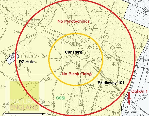
The firing of blank ammunition is banned within 100 metres and the use of fireworks within 300 metres of the public. The practical effect of the rules is that the Army is restricted in the use of the area round the central car park for exercises that involve both parts of the Common.
Safety Zones round the DZ car park
From MoD statements it appears that the Army is prepared to relax these rules for individuals on bridleways. They are not prepared to do this for the DZ central car park, as they are concerned about the concentration of vehicles and visitors in the middle of their training area and view this as an unacceptable risk. It is not certain whether this relaxation also applies to the unregistered tracks: www.elstead.info/path-organisation/investigations/#FiringSafety/
Dog Fouling
Soldiers crawling through the undergrowth are particularly affected by dog fouling, especially on night exercises. It has also caused problems for walkers and cyclists. The area above the central car park shows a relatively high concentration because this is where dogs are let loose when first reaching the Common. Landmarc posted notices about this and there has been some reduction but it is still a problem and Natural England believe that it can adversely affect the SSSI.
Illegal vehicle access & fly tipping.
At most points around the Common cars and trucks are prevented from getting onto the Common by gates. This is not practical at Westbrook Hill because of the need for access by Council and other service vehicles to houses on the Common.
The MoD has not been able to stop motor bikes from using the Common.
PATH objective
At the first meeting of the PATH action group in February the declared objective was to persuade the MoD to keep the central car park open.
Campaign
The closure of the car park was discussed at a meeting between the MoD and local Councillors in November 2011.
The PATH campaign started after the Elstead Parish Council Meeting on January 18th where questions were asked about the MoD intention to close the DZ car park.
Following considerable interest on Facebook a new page was opened to act as a public information channel.
The first Action Group meeting was held on January 23rd: www.elstead.info/path-meetings/Monday-23-1/
Subsequently the legal and geographical situation was investigated. It was found that the legal situation on public rights of access, ownership and the extent of registered Common Land is complex and that there seems to be no legal path to prevent the MoD from closing the car park or controlling access to unregistered paths: www.elstead.info/path-organisation/investigations/#JamesTaylor/
Ownership of a small area of Common Land at the junction of Houndown Bottom and Truxford Lane was checked but was eventually found to be owned by the MoD and within the SSSI, so there was no possibility of developing a car park on that site.
Jenny Else (Waverley BC) and Pat Murphy (Elstead PC) met Col Bishop (MoD) and other Landmarc and MoD staff on February 1st.
www.elstead.info/path-meetings/mod-meeting-1-2-12/
Leaflets were printed and distributed around Elstead and some neighbouring villages.
Articles were printed in the Farnham Herald and the Surrey Advertiser.
An on-line petition was launched on the Elstead Community website.
A second Action Group meeting was held on Feb 7th to discuss progress and organise the Public Meeting: www.elstead.info/path-meetings/Tuesday-7-2-12/
An opinion survey was designed and printed for distribution at the Public Meeting and elsewhere.
The Public Meeting was held in the Elstead URC on February 10th with an attendance of 96. The activities of the PATH action group were universally approved (Appendix). The MoD proposals for a replacement car park were discussed and the attendees voted strongly for a position at or near the Truxford Lane/Woolfords Lane crossroads: www.elstead.info/path-meetings/public-meeting-10-2-12
A Screen was displayed at the Elstead Cinema during the interval and survey forms distributed.
An article was submitted for publication in the Elstead Village News.
www.elstead.info/elsteadnews/path-organisation/press-reports/
Following the Public Meeting further investigations have been made into the proposed MoD options for a replacement car park. This includes site inspections, finding suitable maps and taking photographs.
A second article has appeared in the Farnham Herald www.elstead.info/elsteadnews/path-organisation/press-reports/
MoD proposals
The original MoD proposal was for a car park at the old Polish Camp across the Thursley Road from Hankley Common and separated from it by the very steep Houndown Ridge. This was deemed by PATH to be dangerous and totally unsuitable. Early public reactions made that absolutely clear.
At the meeting between the MoD and local Councillors on Feb 1st the MoD gave a short presentation explaining their concerns and made proposals for three new options for a replacement car park, abandoning the Polish Camp option: www.elstead.info/path-meetings/mod-meeting-1-2-12/
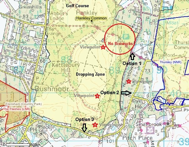
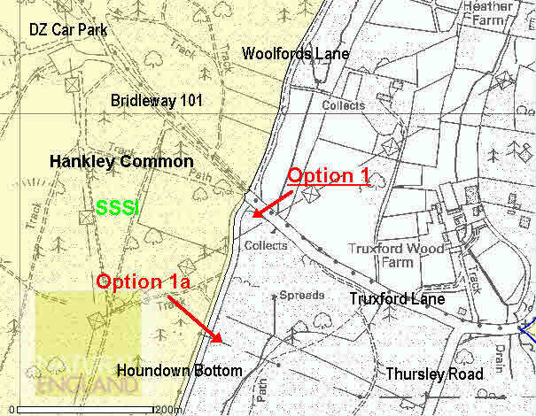
Option 1 is at the Truxford lane Woolfords Lane crossroads. This is a rough piece of land with some medium sized timber and scrub on the edge of a pond and may become boggy in wet weather. It is about 400 metres from the present car park and is the best option for access by elderly and disabled people as the route to the DZ viewpoint is up the tarmac surfaced lane.
- Houndown Bottom & crossroads (Option 1) - Currently PATH preferred option for a car park. Outside SSSI. May receive local residents' objections. Option 1a is a possible alternative.
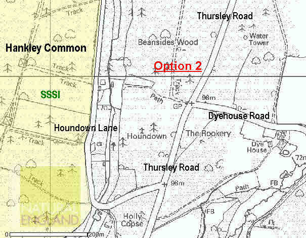
Option 2 is on the southern end of the Houndown Ridge to the east of Hankley Common. This has excellent access onto a firm level track from the Thursley Road opposite Dyehouse Road. It is not the MoD preferred option as there is an Army Command Post on the Houndown Ridge. The ridge itself has a number of firm level tracks through mature woodland. There is one viewpoint next to the Command Post. The area has walks suitable for children, elderly and disabled people but access to Hankley Common is down very steep paths which makes it unsuitable for horse riders. Cyclists apparently find it challenging!
- Houndown Ridge (Option 2) - Only suitable for people who want to walk on Houndown Ridge and for very active walkers accessing Hankley Common. Not the MoD preferred option because of a Command Centre on the ridge.
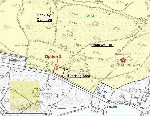
Option 3 is off the Thursley Road, West of Pitch Place. It is fairly level but rough with reasonable access from the road. It is convenient for horse riders as it is at the southern end of Bridleway 108. It has access to some very pleasant firm and fairly easy walks on the hill to the Northeast with superb views to the Southeast and Southwest. There is another viewpoint, with equally good views to the North and Northwest over the Drop Zone. This option is in the SSSI and may not be suitable for a permanent car park for that reason. This car park could be at least trebled in size by restoring the part closed earlier by Landmarc.
- Pitch Place (Option 3) - Suitable for permissive car parking, not for a formal car park. In SSSI, easy access for thieves. Good easy access to southern end of the Common.
Disadvantages of MoD options
It is unfortunate that none of the MoD options offers the same easy access to the viewpoints overlooking the Dropping Zone given by the present car park. This will particularly affect the elderly and disabled and parents with young children.
Use of Bridleways.
The MoD is very definite about the use of the registered bridleways and unregistered tracks. The bridleways can be used at any time by the public. The public are permitted to use the tracks unless they interfere with military training. Horse riders with permits can also use them.
Cyclists are legally restricted to the bridleways but the MoD would not object to them riding on made-up permissive paths. Sandy tracks are out of bounds partly for conservation reasons.
Change of PATH objective
If it is not possible to persuade the MoD to keep the central car park open, Option 1 is the preferred option for PATH. An alternative (1a) has been suggested of a car park off Houndown Bottom, 200 metres south of the crossroads. The area is smaller than the present car park and slopes gently down to a wet area. It is in mature woodland, with a path running North-South through the woods and another leading east onto Houndown. Access to Hankley Common is through a gate and up a sandy track to the ridge, a little steep in parts. This car park is about 500 metres from the current car park, so is less suitable for elderly and disabled people than Option 1.
Car parking is also possible at various points along Houndown Bottom/Lane and the eastern verge is registered Common Land.
Opinion Survey
A printed opinion survey was issued at the Public Meeting and others have been distributed elsewhere. An online survey is also being run. It should be possible to merge the results.
Petition
An on-line petition was launched at the start of the campaign and has so far attracted 572 signatures.
[TOP of page]
