The following issues are the main focus for objections:
Highways and Site Access
With the potential for a further 195 households, each with at least two vehicles, the development is likely to have a significant impact on the local road network, traffic congestion and parking in the town centre. The proposed access which truncates the The Lakes Rd in favour of a through way across from Baldwin Road is unworkable considering the volume of traffic which already uses this route as access to adjoining roads. In particular, residents of Baldwin Road have to park vehicles on both sides of the road as there is no alternative. Any proposal for this access arrangement could result in parking restrictions on Baldwin Road and road safety issues. Gladman's proposal of a roundabout at the irregular junction of The Lakes Road, Dry Mill Lane and Richmond Road is also unworkable due to lack of space and visibility issues.
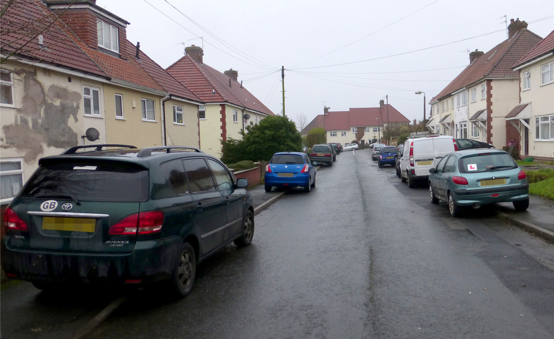
Baldwin Road:
The proposed site main access.
Flooding and Drainage
The inevitable result of a housing development with hard landscaping is that heavy rainfall on the slope will overload any drainage system, including a 'balancing pond'.This could lead to damage to the land below the site and potentially, flooding, mud and debris on Dowles Rd, with the risk of ice on the road in the winter. Run-off and flooding after heavy rainfall are significant issues in Bewdley and the Severn Valley. A proposal to pump sewage uphill to meet the existing system is a concern.
Ecology and Wildlife
Our local expert has studied the fields and hedgerows of the site, and the adjacent Wyre Forest, a site of special scientific interest, for more than 20 years. He has recorded many species, some of which are endangered, including: skylarks; moths; butterflies; bats; owls; newts and the plant life and insect life which sustains them.
Landscape Value
This site has been officially described as a protected landscape (as specified by the CPRE) because it has 'high landscape value'. There are many long views of and from this site which will be adversely affected/obstructed if this development goes ahead. Any development would be visually prominent across the Severn Valley, would detract from the character of the landscape, would breach the strong settlement boundaries and destroy the buffer between Wyre Forest and the existing settlement.
Wyre Forest District Council website makes following statement in relation to the Bewdley Conservation Area:
"The Conservation Area is at the heart of the town of Bewdley that is itself set in and hidden by unspoilt undulating countryside. The Area includes a large proportion of the town and in places abuts open countryside; hence the rural setting of the town is an important component of its character and in turn that of the Conservation Area. Much of this countryside was recognised in the Worcestershire County Development Plan during the 1950s as being an Area of Great Landscape Value, and has been recognised in successive Local Plans as having high local landscape quality. To the west, north and south lie the Wyre Forest and its outliers, which are recognised as being of national importance to nature conservation. The urban fringe to the east of the river is entirely allocated as Green Belt. It is important to conserve the rural setting of the town and Conservation Area, and in so doing to recognise the interrelationships between the Area and overall setting."
Right of Way
The well-used rural footpath, BW518, has been a feature of life in the area for hundreds of years. It was used as a route to Dowles Church (formerly St Andrew's) and was also known as a the 'cherry orchard path' and a 'coffin path'. Another significant historical use, which we still enjoy today, is as a route to the River Severn; there are legends of smugglers who frequented an inn known as the Boar's Head, on Dowles Rd, which is now known as 'Severn Heights', a private residence.
The path is still walked by many people on a daily basis and is promoted as a route to follow from Bewdley town for its 'glorious views'.
Traffic Congestion and Air Quality
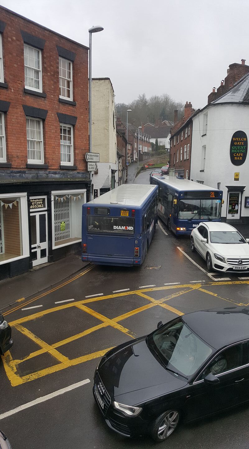
Welch Gate is a very narrow road with single-file pavements where traffic regularly mounts the pavements in order to progress; vans, lorries and buses cause gridlock several times a day. Added to this is the air pollution which results in higher than acceptable levels of Nitrogen Oxide. The area is the second most polluted in Wyre Forest District and has been designated as an Air Quality Management Area.
This Junction is in the heart of the Bewdley conservation area so there is very little scope of improvement measures.
This picture was taken on a weekday in February. During peak times in the holiday season when the town's attractions are all open the situation is often far worse. The proposed development would result in hundreds of daily extra vehicle movements through this already problematic junction.
Jobs and Services
These are limited within the town of Bewdley and it is acknowledged in Core Strategy DS03 that, because of this, development within the settlement boundary should be limited. This proposal relates to open countryside and would still be considered to be unsustainable in the context of employment and service provision within Bewdley.
Impact on Schools
It would not be unreasonable to suggest that 195 new family homes might generate an increase of at least 200 children. The increased demand on school places would be unsustainable. Bewdley High School and both primary schools are full.
Impact on Medical Centre
There have been recent ward closures in the the local Kidderminster Hospital. Any increased demand on Bewdley's GPs and other overstretched health services would be unsustainable.
Impact on Quality of Life
The proposed development would inflict an unwanted and dramatic change on the character of the neighbourhood which lives in harmony with the green space, appreciates the well-used rural footpath and the landscape of the Severn Valley. In line with Wyre Forest DC Core Strategy Policy DS01 and the response to the Neighbourhood Plan consultation, Bewdley's community, as a whole, do not want to see any more large-scale housing development and certainly not on a landscape that is so much appreciated and essential to well-being as this one.
National Planning Policy Framework
The proposed development is contrary to NPPF, paragraph 49, which states there should be a presumption in favour of sustainable development which means approving proposals that accord with the development plan. This proposal is contrary to NPPF (49) because Wyre Forest District Council's housing land supply (April 2016) incorporating objectively assessed housing need from evidence contained in the 2016 Strategic Housing Market Assessment is shown to be 5.9 years. The policies within the current development plan are therefore up to date and carry significant weight in determining this application.