Restoring Your Railway Fund: Isle of Wight railway reopening study
IWBRUG response to stakeholder consultation:
The Isle of Wight Bus and Rail Users’ Group (IWBRUG) is pleased to respond to the stakeholder consultation as part of the study of options for the future development of railways on the Island.
The IWBRUG exists to promote the interests of bus and rail users in the Island and to campaign for improvements in public transport. We work to improve the lot of those for whom it is a necessity and to encourage its wider use. Our interests range from the general, such as concessionary fares, to the particular, such as co-ordination between bus and ferry services and Island Line trains, down to the detail of specific routes in local districts.
We hold members' meetings every month in Newport and twice a year - (normally January and July) - we organise a public meeting, where representatives of the bus and train operators and the council attend to address the public, answer questions and outline service changes.
The options under consideration are re-opening of the routes from Ryde – Newport and Shanklin – Ventnor. We would like to make the following comments and suggestions regarding these options.
Ryde – Newport
The Ryde – Newport corridor currently has a good bus service which runs every 10 minutes. The most serious issue affecting public transport travel on the corridor is the traffic queuing delay westbound on Fairlee Road and Staplers approaching Coppins Bridge junction, as shown in the picture below. This delay has caused bus travel times to increase from 30 minutes in 2005 to 35 minutes in 2020 and up to 42 minutes in the morning peak. This also affects travel from East Cowes – Newport. Any improvements on this corridor should provide quicker public transport travel times for most passengers.
A reopened railway could provide a fast direct link from the Newport to Ryde Esplanade and Pier Head for onward connections to the mainland. In 2020 electric trains achieved an average speed of 23.7mph between Ryde St John’s Road and Shanklin. If the new rail route could achieve this between Ryde St John’s Road and Newport (based on the original track distance), then a 23-minute journey from Ryde Esplanade would be possible. This would represent a 45% travel time saving compared with the present morning peak bus journey of 42 minutes.
This level of saving could encourage some car users to transfer to rail. For example, motorists travelling to Newport from the East Ryde/Seaview/St Helens/Bembridge areas could reduce their journey times by using the Park & Ride site at Ryde St John’s Road station. Any resulting reduction in road traffic could reduce congestion and pollution levels on the main Ryde – Newport road, improving the air quality for local residents, as well as reducing carbon dioxide (CO2) emissions.
However, travel from Ryde Esplanade and Pier to Newport comprises only a small proportion of bus passenger demand on the corridor. There may not be sufficient demand for travel between these locations to warrant a new rail service.
A large majority of the bus passengers on the corridor board at stops in the west Ryde, Binstead and Wootton Bridge areas, which would not be served by a reopened railway. A railway would not therefore improve conditions for most of the travellers on the corridor and may not be the best option for improving public transport in the area.
We believe that a better option would be to utilise part of the old Ryde – Newport railway alignment parallel to Fairlee Road from the solar energy panels to Halberry lane, to provide a westbound guided busway as shown in the map in Figure 1 below. This would enable buses to by-pass 0.9km of road on which there is often a queue of traffic, particularly during the morning peak period.
As the original railway line was only single track, there is probably only space available for one lane of busway, together with a parallel cycle route. However, the eastbound buses are much less delayed on this section and could therefore continue to use Fairlee Road.
Access for passengers to the Medina College and Leisure Centre, a major trip attraction, will be essential. A stop on the busway with pedestrian access would need to be provided.
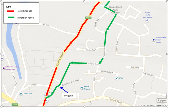
West of Halberry lane the railway alignment has been encroached upon by residential properties, which would probably prevent its use for a busway. However, possible new routes for buses from Halberry Lane into Newport, aimed at reducing travel times by avoiding queuing delays, should be investigated. Possibilities might include a diversion for westbound buses via Halberry Lane and Victoria Road, as shown in Figure 2 below.
These measures could reduce travel times to Newport for passengers from Ryde and also East Cowes on route 5 by up to 7 minutes in the morning peak. The resulting saving in resources (buses and drivers) could also help to enable service frequencies to be increased on routes from Ryde and East Cowes to Newport - reducing waiting times at stops for passengers.
Figure 1: Guided busway alongside Fairlee Road
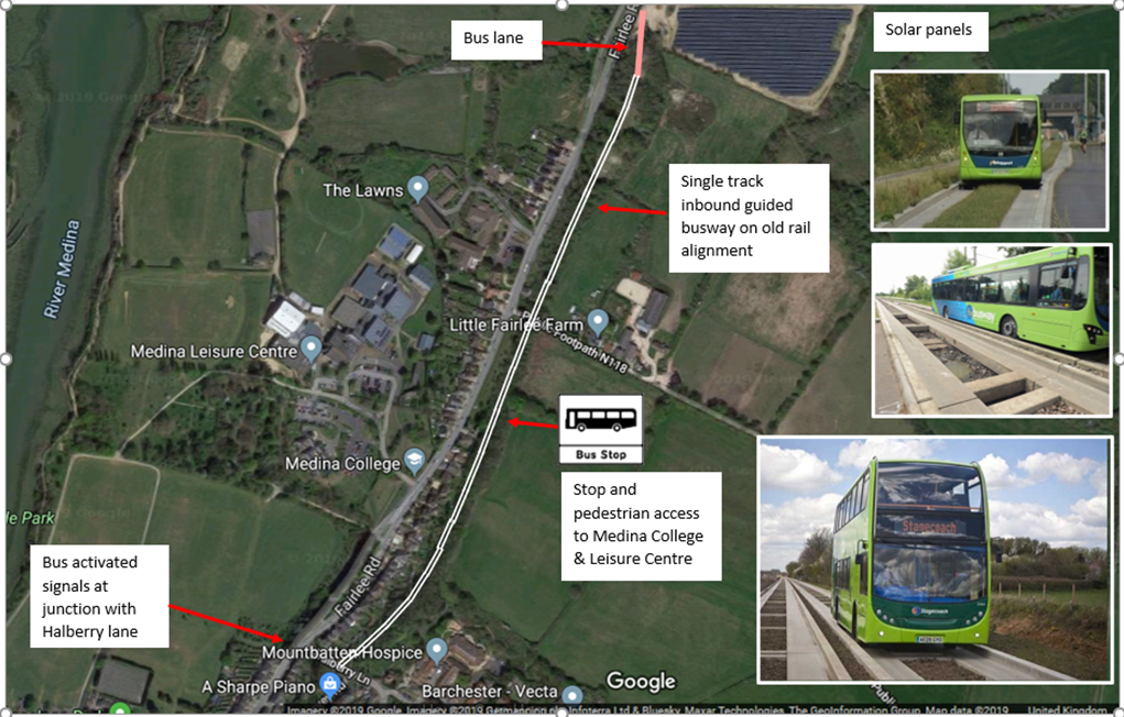
Figure 2: Halberry Lane diversionary route
On Victoria Road south of Saint Paul’s View Road, a bus gate, possibly using bus-activated bollards, would be needed to enable buses to pass through the pedestrian/cycle only section.
Shanklin – Ventnor
This section forms part of a wider transport corridor from the South Wight area to Ryde for onward connections to the mainland. Although Ventnor has ap population of only 6,000, the station catchment area could include South Wight villages such as Whitwell and Niton if adequate parking facilities are provided.
Tourist travel to Ventnor from the mainland declined considerably following the closure of this section in 1966 and has remained low despite provision of a half-hourly direct bus service with convenient bus-rail interchange at Shanklin. Reopening the railway could improve public transport access to Ventnor thereby supporting efforts to regenerate the local visitor economy.
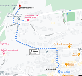
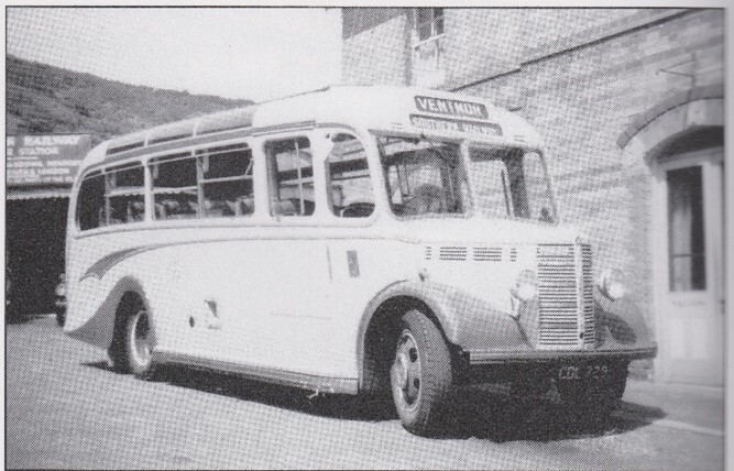
However, the station site is just under 500m walk from the town centre (assumed to be the Boots/Co-op stores), with an uphill gradient averaging 1 in 9 in the outbound direction. Google maps estimates this walk to take 10 minutes (upwards) as shown below left. When the railway was operating a dedicated shuttle-bus was provided at busy times for passengers for whom this walk was not suitable, as shown in the picture below right. To meet current passenger expectations a bus service to the town centre would be needed. This could be either an enhanced Ventnor town service (route 31), also serving Bonchurch and west Ventnor or a convenient interchange with route 3 services which stops on Ocean View Road near to Old Station Road every 30 minutes. It is important that bus access to the town centre (High Street/Pier Street) is maintained. The bus travel time from there to the town centre Boots stop is currently 7 minutes.
Pedestrian route Ventnor town to station.
Ventnor station to town shuttle bus in 1955
These time savings would be significant as a proportion of the current travel time and would be likely to attract some car users to rail as well as improving accessibility to Ventnor. Any diversion of car journeys between the South Wight area and Ryde ferry/hovercraft terminals to rail could reduce car mileage and consequent pollution/CO2 emissions. The IWBRUG therefore supports this scheme.
To attract passengers a half-hourly Ryde – Ventnor service should be provided by extending the current Ryde – Shanklin trains. A station should be provided at Wroxall to serve the village.
Summary and other possible Island rail improvements
The IWBRUG supports reopening of the Shanklin – Ventnor railway.
For the Ryde – Newport corridor, we do not believe that a reopened railway line would address the most serious travel issue affecting most of the public transport users of this corridor – which is the delay from westbound queuing traffic approaching Coppins Bridge junction. Instead, we would support a busway scheme to reduce westbound bus travel times by enabling buses to avoid the queues on Fairlee Road. A busway could possibly utilise part of the former rail alignment which runs parallel to Fairlee Road.
These public transport improvements could encourage some car users to switch to rail or bus. Any resulting reduction in car mileage would also reduce CO2 emissions, thereby contributing to Government policy objectives.
In addition to the extensions, we would like to suggest the following possible improvement measures to the Island Line for consideration:
-
Access for Persons with Reduced Mobility to platform 2 (southbound) at Ryde St John’s Road station, which could comprise a new footbridge with lifts;
-
Larger sheltered waiting areas on platform 2 (southbound) at Ryde St John’s Road station and on platform 1 (northbound) at Sandown station;
-
Replacement of the deteriorated wooden screen at Ryde Pier Head station to give greater wind protection for passengers and a better appearance;
-
Operation of 3 trains/hour (20-minute interval) service at busy times;
-
A new point giving trains access to the disused platform at Ryde Pier Head, which would enable train doors to open on both sides, speeding up boarding/alighting and reducing delays at busy times; and in the longer term,
-
Reinstatement of the double-track sections from:
-
Ryde Per Head – Ryde Esplanade; and
-
Brading – Sandown.
-
This would enable a 4 trains/hour or 15-minute interval service to be run at busy times, which could be warranted in future if travel demand were to increase.
Although the Island Line is remote from the National Rail Network, many passengers travel to mainland stations via the Ryde – Portsmouth passenger ferry. Unfortunately, there are issues concerning the ferry service, affecting these passengers. We would like to suggest the following possible improvements to this ferry link for consideration:
-
A Public Service Obligation, with revenue support if necessary, to secure minimum service levels;
-
A 30-minute interval service on Saturdays during school holidays, on Bank Holidays and all busy times so that passengers are not left waiting; and
-
Lower fares and more marketing/promotion of rail travel to the Island.
We hope that these suggestions can be given due consideration in the rail reopening study and in the development of proposals public transport services on the Island.
