
 |
Local Map 1810 -1817 19th century railways and Farnham Station |
The arrival of the railway in 1849 resulted in a wider range of mass-produced goods becoming available to local people. Goods and passengers could be transported quickly and efficiently and in the long term the railway enabled people to work elsewhere whilst living in Farnham. Incoming goods included yellow bricks and slates and these begin to appear as building materials.
Although the popularity of the railway replaced the stage coach, in common with elsewhere, individual local carriers found their business increased as there was a demand for goods to be taken to and from the station. The station soon grew in size, sidings covered the present car park and also the area on the south side of the station now developed as Southern Way. A later extension of the line westwards put Winchester and the south coast within easy reach.
A feature of Farnham at this period was the large number of pubs, largely due to the influx of soldiers from Aldershot camps rather, than as is often thought, to the still flourishing hop trade.
One noticeable effect of the construction of Aldershot Camp was the increase in traffic to Farnham station. At that time the way to the station was from the Borough, via Downing Street, on to Abbey Street and then up to the station. This was a tortuous route and there was pressure for a more direct road to the station. After considerable delay, South Street was constructed for this purpose and opened in 1870. At the same time Union Road was laid out to link up with Downing Street. This was the first major change to the medieval street pattern in Farnham town.
 |
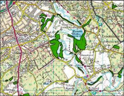
This map, dated 1916, shows the ancient woodland to the south of Farnham that still exists to this day. |
|
|
This map, dated 1934, defined the planned layout of the South Farnham area and the importance of protecting ancient woodland and hedgerows. |
 |
Surrey County Council woodland inventory map This map has been produced by Surrey County Council showing the areas that have been identified as ancient woodland. |

As shown on the Surrey Woodland Inventory map the fields to the west of Waverley Lane are in close proximity to Ancient Woodland on two sides and abut a stand of mature oak on the third side adjacent to Waverley Lane. Additionally, ancient trees border the footpath that bisects the fields. Substantial parts of the fields therefore, are not only designated as Ancient Woodland (shaded dark green), but also contain veteran trees and fall within the flood plain. Historically, the woodland shown was used as grazing land for the pigs owned by the monks of Waverley Abbey. The pigs were encouraged to eat the fallen acorns to keep the tree canopy clear and to allow freedom of growth for the more mature trees. This is still being done today in other woodland sites.
The NPPF is quite clear in Para 118 point 5 “planning permission should be refused for development resulting in the loss or deterioration of irreplaceable habitats, including ancient woodland”.
This point is further strengthened by Natural England in their document “Standing Advice for Ancient Woodland” where they state that “this statement in the NPPF provides clear recognition in government policy of the irreplaceable nature of this habitat”. And they advise that LPA’s should not include development sites with the potential to damage ancient woodland within their Local Plans, unless they are clearly able to meet the tests of the NPPF.
There are still occasions where native and ancient woodland is threatened by development and many woods suffer attrition through incursions at their boundaries. Even if the woodland itself is protected, it can suffer serious disturbance where houses or roads are built right up to its margins, both directly from the impact of development or indirectly through changes to drainage. Thus the NPPF makes no differentiation in the treatment or protection of veteran trees found in, or outside of, ancient woodland.
The document “Standing Advice for Ancient Woodland also notes a number of effects that are likely to occur when land adjacent to ancient woodland is developed. These include disturbance to breeding birds, recreational pressure, light pollution which affects bats, and encroachment of residential gardens leading to the displacement of habitat for creatures such as adders, grass snakes and slow worms.
In addition they note the effects that cannot be mitigated against or negated by financial payments which include:
- reduction in the area of other semi natural habitats adjoining the ancient woodland
- increased exposure to pollutants from the surrounding area
- changes to the local hydrology
- change to the landscape context for ancient woods and veteran trees
- the predatory impact from cats made on the local bird population, on bats and small animals such as voles and shrews, has been well documented. This impact cannot be mitigated against by the developer, as denying the purchaser the right to keep a cat on their property is not enforceable.