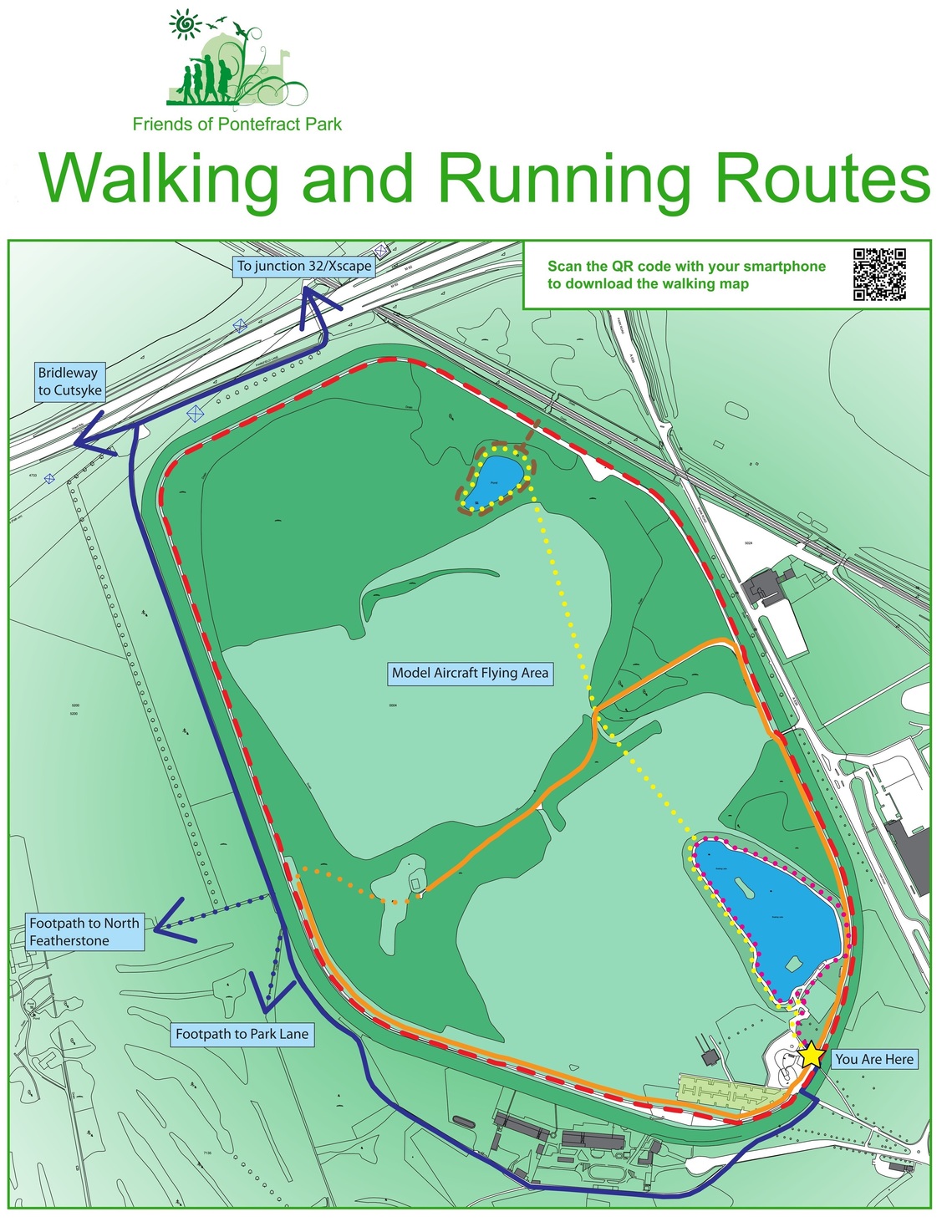
The two mile circuit of the racecourse is a popular walking and running route, and there are several alternative routes available. Please avoid walking on the racecourse. Pontefract Racecourse Company is concerned that paths could be worn on the racecourse, particularly at popular crossing points or around the inside of the racecourse. Worn paths would present a hazard to the racehorses.
Pontefract parkrun takes place every Saturday at 9am. It is a 5k (3.1m) circuit around the Racecourse and lake. All ages and abilities are welcome, including walkers and gentle joggers. Up to 600 participants attend. Go to Pontefract parkrun website: parkrun.org.uk/pontefract and Facebook page for up to date information.
1. Racecourse circuit 2 miles (red). There is a partly surfaced path around the inside of the racecourse with a gentle incline. The path is uneven in places and not particularly friendly for pushchairs or wheelchairs. The "Peter's Lost Peregrine" trail is located around the circuit.
2. Lake circuit 0.6 mile (pink). This is a short, flat walk around Pontefract Park Lake suitable for those with limited mobility, suitable for wheelchairs and pushchairs although there are areas of uneveness.
3. Two lakes walk 1.4 miles (yellow). This route passes along the side of the lake and then across the grassed area in the centre of the Park to the smaller irrigation pond at the north east corner of the Park, around the pond and back. The walk across the playing fields and around the pond is not a made-up path and may be boggy in places. Also, the Council have adopted a policy of not mowing all of the grassed areas, although a path is usually mowed. This route crosses the edge of the area used by Pontefract and District Aeromodellers, so be aware of flying model aircraft on some days. There are warning signs in place.
4. Cut across 1.5 miles (orange). This route takes the path round the inside of the racecourse and then cuts across the middle of the Park, taking the partly surfaced path to the Aeromodellers' container. This route is not suitable for wheelchairs or pushchairs and the western end of the path is not marked and may be boggy at times.
5. Small lake/pond diversion 0.25 miles. Diverting from the path around the inside of the racecourse adds 0.25 miles to the route.
6. Cycle track to Junction 32 and Xscape 1.8 miles (blue). This route takes the tarmac surfaced road behing the Racecourse buildings and the western side of the Park, meeting the bridle path to Cutsyke at the north west corner of the Park next to the M62. Turning right to walk parallel to the motorway meets the subway under the M62 which leads to Junction 32 retail outlet and Xscape via a gated pedestrian crossing across the railway line near Glasshoughton Station.

