(Click the underlined words for links to more information.)
Burrington Combe is a carboniferous limestone gorge which contains the entrance to many caves including Sidcot Swallet, Goatchurch Cavern and Aveline's Hole, which is a Scheduled Ancient Monument. It contains cave art from the early Mesolithic period and is the earliest, scientifically dated cemetry in Britain; more than 10,000 years old. The Combe has provided evidence of human occupation from the Upper Palaeolithic period, the Bronze Age and Roman period. It also has the 'Rock of Ages' named after the hymn by Augustus Montague Toplady, Curate of Blagdon between 1762 and 1764, although there is some debate about whether he actually drew his inspiration from sheltering in the cleft.
There are various explanations of the name 'Burrington'. One is that it means 'the villa and an enclosure' from the Old English 'bur, end, tun'. Other explanations are based on the village's historic links with the Parish of Wrington, e.g. 'by Wrington' or 'Burgh of Wrington' or even 'Buryingtown' because it had an extensive graveyard associated with a chapel of Wrington.
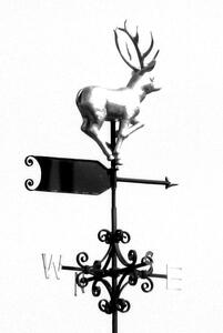
In the 15th Century, the village was called Beryngton and was involved in lead mining. The Church of the Holy Trinity (see also separate pages on this web site) is from the 15th Century and the tower contains a bell dating from 1713. The church was restored in 1884. It has a notable weathervane of a Roe Deer created and presented in 2000 by Robert Hobbs who was a local resident and a Gold Medal Winner of the Worshipful Company of Blacksmiths.
Other notable local landmarks include Langford Court, which was built in 1651 and renovated in the early 19th century and again in 1875; and the former Rickford Baptist Chapel (now a Masonic Hall for the Forest of Mendip Lodge).
The Langford History Group provides a wealth of information on local history through its publications, meetings and web site: http://langfordhistory.com/lhg/
Burrington Parish Council is supporting the Langford History Group in its efforts to conserve important historical maps of the area including the John Rocque survey of 1739 and 1838 Burrington Tithe Map. The Group's web site also provides access to the 1885 Ordnance Survey map of Langford.
Extract from the 1838 Burrington Tithe Map:
See Langford History Group Web Site for more details and better images.
