
A History of Bulmer by Ashley Cooper
Geological and natural processes have largely fashioned Bulmer's rolling terrain.
Some seventy million years ago, chalk and flint were formed in the sea, which then covered our area. About fifty five million years ago London Clay—which is today used for making bricks—was deposited by rivers into a later sea, which lay over Bulmer. Around 600,000 years ago stones and pebbles were left by the River Thames when it flowed across Bulmer and North East Essex.
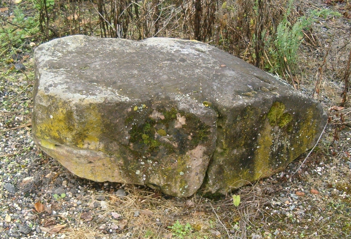 |
The great 'Anglian’ Ice Sheet, (which may have been several hundred meters thick), crossed our district some 450,000 years ago. This resulted in the deposition of sands and 'glacial erratic' boulders, together with the creation of the 'chalky boulder clay' which covers parts of our parish. |
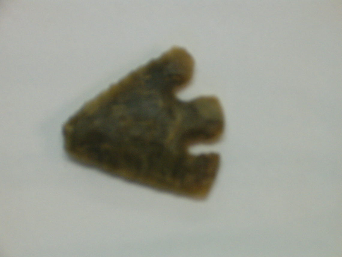
With the retreat of the last ice age about 10,000 years ago, our local countryside slowly changed from tundra to thick forests. Hunter-gatherers followed rivers and open areas until around 3000B.C. when more settled agriculture began to be practiced in Southern England. Archaeological analysis of soils in the Belchamp Valley, suggests that they were washed down there as erosion, following the clearance of woodland from the top of the hills in these centuries. Discoveries of flint tools and a flint arrowhead further attest to human activity in Neolithic times.
Shards of a Bronze Age urn have been found close to Wesborough Hill. Although Iron Age finds are scarce at the moment, significant areas of our parish must have been farmed during the first millennium B.C. By the birth of Christ we can imagine a scattered network of Celtic homesteads and trackways across our area.
From the Roman era, (A.D 43-410), there is evidence of three separate Romano-British 'hut sites' from the southern and western fringes of the parish. The major Roman settlement, which existed at Gestingthorpe, almost adjoins the parish boundary with Bulmer. The Roman road, which connected London—Chelmsford—Braintree—Gestingthorpe—Long Melford—Brancaster (on the north Norfolk coast), almost certainly passed within half a mile of Bulmer Street.
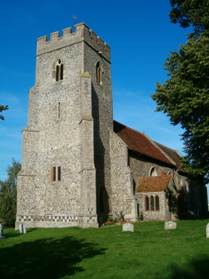
With the coming of the Anglo-Saxons from around circa A.D 450, place names provide clues to our village's heritage. Bulmer itself is thought to mean ‘Bull's Pond'. Part of the parish was in the 'half hundred' of Thundersley—or 'Thunor's Hill’. (Thunor was the Saxon god of Thunder, War and Farming.) In 'Bulmer; Then and Now' , Basil Slaughter pondered whether ‘Thunor's Hill’ was the knoll where St.Andrew’s Church was later built, and which has stunning views and a commanding position.
In the Domesday Book of 1086 there are references to four manors in Bulmer. Goldingham, Smeetham, and Binsley, (the latter being in the Kitchen Farm - Ballingdon Hill area), together with an un-named manor considered to be Butlers Hall.
From 1178 comes our earliest reference to a Church in Bulmer, when a dispute over tithes occurred with neighboring Brundon.
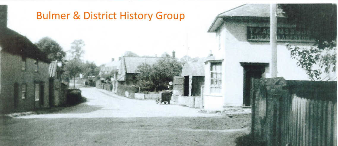
The latticed lanes and track ways that we know today were almost certainly in existence in late Saxon/early Norman times. However Bulmer Tye, (which means 'common' or ‘green'), probably gained greater significance following the building of Ballingdon Bridge about 1200. This enabled significantly more traffic to use Ballingdon Hill, thus placing the Tye alongside the direct route from London to Sudbury. With the expansion of agriculture in the same century farmsteads may have begun to develop in this part of the parish. (Later to be manifest in the splendid sixteenth century timber work of Jenkins Farm.)
Medieval Bulmer was thus a parish of several parts. By 1250 its landscape would be largely recognizable to us today, although it would have been more wooded. Extant records from the Manor of Goldingham reveal how accurately fields and woods were being measured in 1314—together with the human misdemeanours which occurred in Bulmer Street!
In the late Middle Ages another large house known as Grandons was built near the Tye, later being superseded by the Auberies. In the eighteenth century the twenty-three acre Tye was used for grazing, cattle fairs and games of cricket, whilst hostelries met the needs of travellers along the road.
Bulmer’s most famous residents are surely Mr. and Mrs. Robert Andrews, owners of the Auberies, who were depicted so exquisitely by the artist Thomas Gainsborough in about 1750. Andrews was an outstanding agriculturalist and committed parishioner.
In 1831, an Enclosure Act resulted in Bulmer's common land being rationalised. It is thought that as a consequence, allotments were created around the parish. Today several have been converted to wildlife habitats, (such as ‘Little Dean Spinney’ near Upper Houses, and ‘Bakers Field’ which adjoins the School). Others are used as paddocks for animals. All provide a pleasant diversity within the village.
Considerable mention has been made of Bulmer’s soils. Not only have they influenced farming and flora, but also the parish’s long tradition of exploiting them for building materials. Flints were used for walls, the London Clay for brick and tile making, and the sand and chalk for making mortar. (A medieval tile kiln existed not far from today’s Brickyard, whilst in 1425 the tithes of one Bulmer limekiln were allocated to the Vicar.) The deep depressions of the old Chalk Pits still exist and can still be seen on several walks.
The flint works in St. Andrews Church and other walls, the local aFlint walls, locally made roof tiles and both red and white bricks, together with timber framed buildings, thatched roofs and examples of pargetting, all contribute to the wonderful diversity of Bulmer's architectural heritage. A walk along Bulmer Street provides a delightful glimpse of the visual richness and variety that characterises the village.
Acknowledgements
'Essex Rock' by Gerald Lucy. Published by Essex Rock and Mineral Society 1999.
[A superb introduction to our local geology.]
'The Place Names of Essex' by P.H Reany. Published by English Place Names Society 1935 & 1976. [The standard reference book]
'Bulmer Then and Now’, edited by Basil Slaughter. Published by Bulmer W.E.A. 1979. [The definitive guide to Bulmer’s history.]
'Guide to the Church of St. Andrew, Bulmer' by Richard Slaughter. [A most informative booklet, available in the Church.]
'The Essex Landscape' by John Hunter. Published by Essex Record Office 1999. [Another excellent reference work, especially helpful in understanding the likely evolution of parishes in north east Essex during the Middle Ages.]
‘Sudbury: History and Guide’ by Barry Wall. Published by Tempus, 2004. [An outstanding publication, invaluable in the above article for information on the building of Ballingdon Bridge.]